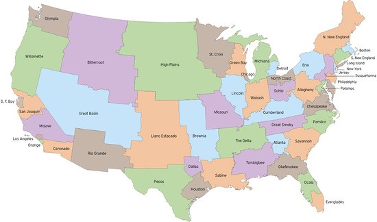
Democrats around the nation are feeling a lot of ire at America's electoral system lately. Even though Dems have still got a 59-41 majority in the U.S. Senate, the election of Massachusetts Republican Scott Brown means they won't be able to get health-care reform–which was crazy-close to being passed–completed the way they had wanted. What's more: The 41-vote minority that's seemingly calling all the shots in the senate are, by and large, from lil' bitty states where (relatively) no one lives.
So you'll excuse liberal bloggers for doing a little day-dreaming about the way things could be. Hence, that map up there.
]
I saw it on the blog of the Atlantic's James Fallows, but it's actually a product of fakeisthenewreal.org. The map purports to redraw state boundaries to reflect equal populations–and therefore, equally sized constituencies for each senator.
The noteworthy thing for us is that while most other regions of the country have been radically sliced and diced (check out San Diego–it now includes all Imperial County and Hawaii), “Orange” remains as its own distinct unit. Apparently, though, the county's boundaries were widened just enough to get the population count in to the 5 million range. Still, pretty cool. We're our own state, in Imaginary America! Who would our two senators be? Perhaps two of Gustavo's least reprehensible politicians? Nah, just kidding, they'd likely be Mickie Mouse and Miguel Pulido. Neither ever go away!


