The Greenland Ice Sheet is expected to erode much quicker–and lead to sea levels rising much higher–based on revelations included in UC Irvine-NASA research published Monday.
]
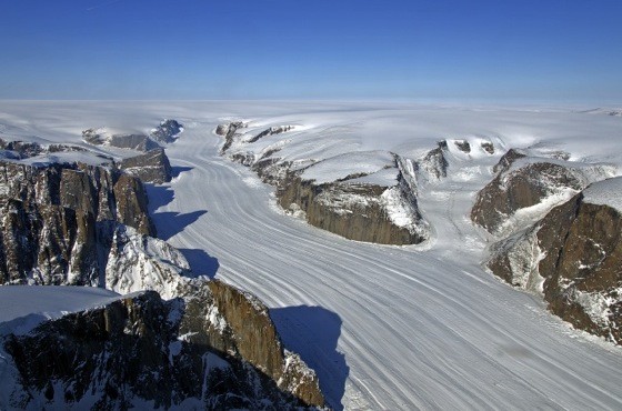
The work, published in Nature Geoscience, shows previously uncharted deep valleys stretching for dozens of miles under the Greenland Ice Sheet. Think of the long, deep valleys connecting the ice cap to the ocean as autobahns for melting ice. The new UCI-NASA mapping uncovered hundreds of them, all previously unknown.
“The glaciers of Greenland are likely to retreat faster and farther inland than anticipated–and for much longer–according to this very different topography we've discovered beneath the ice,” says lead author Mathieu Morlighem, a UCI associate project scientist, in a university statement. “This has major implications, because the glacier melt will contribute much more to rising seas around the globe.”
I've read and re-read three times trying to figure out how Morlighem and his team came to that topography, which includes Greenland's rugged, rocky subsurface that descends as much as 3 miles beneath the thick ice cap. It has something to do with improved measurements of Greenland's topography since 2009 thanks to NASA Operation IceBridge flights, as well as a novel “mass conservation algorithm” Morlighem developed that combined the previous ice thickness measurements with information on the velocity and direction of its movement and estimates of snowfall and surface melt.
“Operation IceBridge vastly improved our knowledge of bed topography beneath the Greenland Ice Sheet,” says co-author Eric Rignot of UCI and NASA's Jet Propulsion Laboratory in the university release. “This new study takes a quantum leap at filling the remaining, critical data gaps on the map.”
Morlighem, Rignot and their co-authors Jeremie Mouginot of UCI and Helene Seroussi and Eric Larour of JPL also reported stark new findings last week on accelerated glacial melt in West Antarctica. Call them the good news club. Morlighem posted this video on YouTube which shows Greenland's surface topography and ice velocities on the left and bed topography beneath the ice sheet inferred from mass conservation on the right:
Email: mc****@oc******.com. Twitter: @MatthewTCoker. Follow OC Weekly on Twitter @ocweekly or on Facebook!

OC Weekly Editor-in-Chief Matt Coker has been engaging, enraging and entertaining readers of newspapers, magazines and websites for decades. He spent the first 13 years of his career in journalism at daily newspapers before “graduating” to OC Weekly in 1995 as the alternative newsweekly’s first calendar editor.